Harris, C.W., Miller, M.S., Supendi, P. and Widiyantoro, S.,
Journal of Geophysical Research: Solid Earth, (Q1) 125(8), p.e2019JB018854.
2020.
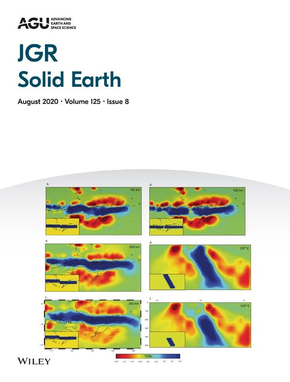
We use traveltimes from a temporary seismic deployment of 30 broadband seismometers and a national catalog of arrival times to construct a finite‐frequency teleseismic P‐wave tomographic model of the upper mantle beneath eastern Indonesia, where subduction of the Indo‐Australian plate beneath the Banda Arc transitions to arc‐continent collision. The change in tectonics is due to a change from oceanic to continental lithosphere in the lower plate as inferred from geological mapping and geophysical, geochemical, and geodetic measurements. At this inferred transition, we seismically image the subducted continent‐ocean boundary at upper mantle depths that links volcanism on Flores to amagmatic orogenesis on Timor. Our tomographic images reveal a relatively high‐velocity feature within the upper mantle, which we interpret as the subducted Indo‐Australian slab. The slab appears continuous yet deformed as a result of the change in buoyancy due to the composition of the incoming continental lithosphere. Accordingly, there is a difference in dip angle between the oceanic and continental sections of the slab albeit not a gap or discontinuity. We suggest the slab has deformed without tearing to accommodate structural and kinematic changes across the continent‐ocean boundary as the two sections of the slab diverge. These results suggest that deformation in tectonic collisions can be localized along a continent‐ocean boundary, even at depth. We propose that future slab tearing may develop where we observe slab deformation in our study region and that a similar process may take place in collisions generally.